

Home » Santa Teresa Gallura
SANTA TERESA GALLURA
Lungoni
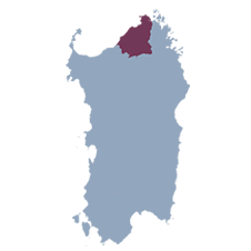
Santa Teresa Gallura, the last Sardinian town on the mainland before the Strait of Bonifacio, enjoys a strategic and fascinating position, characterized by breathtaking views and a unique natural setting. Its foundation dates back to 1801, when Victor Emmanuel I decided to create a new inhabited center in the Longosardo area, dedicating it to his consort Maria Teresa. This act of foundation marks the beginning of a history deeply connected to the sea and local traditions.
The main symbol of the town is the Longosardo Tower, erected at the behest of Philip II of Spain in the 16th century as a defensive outpost against Saracen incursions. The tower offers a wide view of the Strait of Bonifacio, allowing visitors to observe Corsica on clear days. This historical monument is a testament to the strategic and cultural relevance of the territory since ancient times.
Santa Teresa Gallura is also famous for its enchanting beaches, with fine sand and crystal-clear waters, among which the famous Rena Bianca stands out, having been awarded the Blue Flag multiple times for the quality of its waters and services. In the surrounding area, you can explore numerous coves and nature trails, ideal for hiking and sea lovers. This varied landscape attracts thousands of tourists every year, who enliven the town center during the summer season, participating in cultural and musical events organized to celebrate the identity and traditions of the place.
But Santa Teresa Gallura is not just about the sea: it’s also a place rich in ancient history. The nuragic complex of Lu Brandali, with its nuraghe and giants’ tombs, testifies to the presence of human communities dating back to the Nuragic era, offering a journey back in time to understand the roots of Sardinian civilization.
This mix of history, culture, nature, and hospitality makes Santa Teresa Gallura an ideal destination for those seeking not only the beauty of the places but also an authentic experience in one of the most fascinating locations in Sardinia.


ARCHAEOLOGICAL
NATURAL AREAS

Coordinates
Altitude
Area
Inhabitants
Hamlets
Patron Saint
40 meters above sea level
102.29 km2
5086

 e poi
e poi